Israelite Bay is a bucket list trip for many 4WD enthusiasts. It was for us too and last December we ticked it off. Israelite Bay is known for fishing and 4W adventures. It is located nearly 900km east of Perth and is part of Nuytsland Nature Reserve and the Great Australian Bight.

Point Malcolm
Point Malcolm is 25km west of Israelite Bay, so we decided to visit it first, as it was on the way. We travelled there from Cape Arid National Park via Pasley/Telegraph Track.

Pasley/Telegraph Track


The condition of the track depends on the weather. Generally, we found the track much better than we expected, with not much corrugation.


Starting with soft sand, the majority of the track was hard earth with some soft spots and occasional muddy sections. We were quite lucky to travel in good weather. You wouldn’t want to take those tracks when it rains or immediately after, as the track or parts of it become washed out.


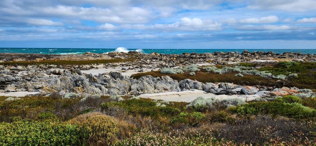
Point Malcolm camp and beach
When you arrive at Point Malcolm you will see a sign indicating a camping area. It is very basic with limited spaces and no facilities at all, so it is important to be self-sufficient.

The actual Point Malcolm is 1km or so further away through the sand dunes. There is a soft sand track that leads there through a steep hill.

We preferred to walk on the beach, which was long, sandy and quite nice with colourful coastal dune plants.


Despite strong easterly winds in late December, we enjoyed our 1-night stay at Point Malcolm. The trip to actual Point Malcolm (not just a campground) is a must, whether you drive or walk there, or you won’t appreciate this place. We were impressed with eroded rock formations, some of which looked out worldly. There were plenty of colourful crabs hiding in rock pools and many water birds above.


Israelite Bay
From Point Malcolm it took us roughly 2 hours to get to Israelite Bay (33km long trip). We saw some washouts (luckily, most of them had alternative tracks to drive around).


There were also a few clay pans and salty lakes along the way. If you are not observant enough and lose track, especially if you drive after the rain, you might be in trouble. So, we took it easy and slow, to be on a safe side.


Israelite Bay Telegraph Station Ruines
Israelite Bay holds a lot of historical value. It is mostly known for ruins of the old telegraphic station, dating back to 19 century. The visit to the ruins is a must and they are quite interesting to see. It felt a bit spooky to walk inside the ruins (our older son saw a snake there too), especially when the weather was so gloomy. Unfortunately, there was no information sign or board about the history of the place there.


Israelite Bay beach and old jetty
Apart from the Telegraph Station Ruines, there is also an old jetty and the graves of former post masters which are worth having a look at at Israelite Bay. The beach itself isn’t particularly nice. It is very weedy, up to half a meter high of seaweed on the beach and at places no sand visible at all.


Pink lake
But the nearby pink lake with salt crystals is quite picturesque.


There are plenty of camping spots around, however we chose not to camp at Israelite Bay and headed back to Cape Arid.

Fisheries Track
On the way back (from Israelite Bay to Cape Arid) we choose the other route and travelled via Fisheries Track. We were told by the ranger that Fisheries Track was in a worse condition than Telegraph Track. We didn’t find this was the case and guessed that it depends on the weather conditions on the day and prior your travel. We found it in much better condition than we expected. It often gets closed when it rains and it was closed just a day or two before we travelled due to bush fires. The wind was strong and it blew the sand over normally heavily corrugated track, so it was quite a pleasant drive most of the track.


For the nature lovers
Nature enthusiasts will find plenty of interesting objects both at Point Malcolm and Israelite Bay. Varanus rosenbergi (below) is very common both in Cape Arid and Nuytsland nature reserve and we saw a few of them.


Birdlife is also abundant there. Below – Pied Oystercatcher (left), Caspian Tern (right).


The wildflowers will delight the eyes of anyone who has the ability to notice them. Below are just a few of them (Boronia spathulata – left, Gompholobium confertum – middle, Jacksonia capitata – right).


And this is us, with the iconic sign of Telegraph Track.

